Mobility Choices
The Mobility-Choices project will make a significant contribution to strengthening sustainable and "soft" mobility in the Lake Constance region by empirically investigating which measures actually bring about behavioral changes.
In particular, cross-border traffic still largely takes place on the road.
This regularly leads to traffic jams and an increasingly critical attitude toward individual transport, which is, however, (still) hardly reflected in everyday behavior. These contradictions can be explained by findings from behavioral economics, which reveal that people often do not make decisions in line with their own idea of a better healthier environment, but are guided by habits or social influences. That's why authorities are increasingly using gentle "nudges" (from the English "to nudge") to move people in a desired direction without patronizing them through sanctions or bans.
The project meets the challenge by creating an empirically sound evidence base for policymakers to identify which measures work when, where, and for whom.
Partners and stakeholders:
Project management: FHV (Contact: Prof. (FH) Dipl. Inform. Thomas Feilhauer)
Institute for Information and Process Management of the FHS St. Gallen (contact: Prof. Dr. Edith Maier)
Kairos gGmbH, Institute for Impact Research (contact: Martin Strele), Bregenz
Source code of the app:
The source code of Mobility Choices is available on Github as open source under GNU AGPLv3
Funders:
Mobility Choices was an EU project in which the State of Vorarlberg and the Canton of St. Gallen participated. The project was funded by the Alpenrhein-Bodensee-Hochrhein Interreg program from 2016 to 2019.
Result details on the app to capture paths and display routes
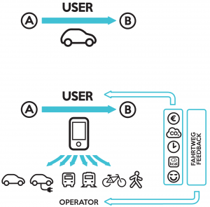
As a result of the research project, the app available for iOS in Appstore and for Android in Playstore was developed, which
- records user paths on demand and thereby
- automatically detects the means of transport used,
- analyzes the route according to the criteria of environment, health, cost, time and
- displays alternative connections that better match the weighted criteria;
- displays routes to users,
- which are evaluated according to preferences based on the criteria of environment, health, cost, time,
- as alternatives for routes already traveled or
- for the planning of new routes.
The user can thereby create his own profile, in which he:
- specifies his preferred means of transport and additionally specifies criteria that are taken into account for the route search, e.g. Max. Number of transfers, Max. Waiting times, max. route lengths for walking and bike distances
- sets his own priorities for his routes in terms of environment, health, cost, time, which are used to evaluate his routes and the proposed routes
The recorded routes can be edited by the user in terms of the means of transport used and intermediate destinations, which in turn are taken into account in the search for alternative routes. The user can split the routes and finally release any (partial) routes for evaluations by regions or municipalities involved in the project. The route data is anonymized and helps to analyze real traffic flows and improve the transport infrastructure.
The app can therefore be used, for example, to determine real movement profiles of participants in traffic surveys without them having to draw on their routes from memory or personal records, which experience shows leads to a certain inaccuracy. For the analyses, the actual route information with all intermediate destinations, detours, start, end and waiting times, as well as the means of transport used are thus available for each section. This makes it possible to analyze traffic behavior much more precisely than with conventional means.
The advantages for the user are that he can use the app to display routes with the means of transport that best meet his expectations in terms of the criteria selected in his profile: environment, health, costs, time. The functionality is currently limited to the Lake Constance area; the routing is specifically adapted to the public transport offer in the Austrian and Swiss Lake Constance region as well as the city of Lindau.
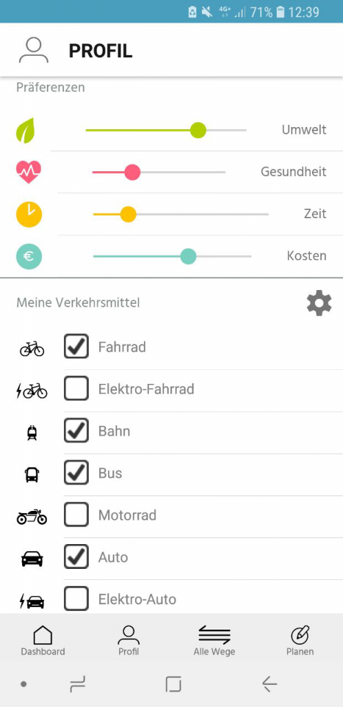
Each app user has the option to personalize their profile. Thereby, there is the possibility to define the importance of the criteria "environment", "health", "costs" and "time" according to his own preferences, to select available means of transport and also to set threshold values (e.g. maximum walking distance, maximum number of transfers or maximum waiting times for trips by public transport, etc.).
The paths traveled by app users are recorded at the touch of a button ("Record path"). After completing the route recording, the recorded route first appears under "All routes" in the "Recordings to be evaluated" section. After pressing the "Evaluate" button, the path is automatically analyzed in relation to the means of transport used. This can take several seconds to a few minutes. After pressing the Synchronize button (circle symbol in the upper right corner), the analyzed route is loaded onto the smartphone and appears in the "Recordings to be released" section. Here the user can edit the path (name, means of transport, split path) and decide whether he actually wants to release the path. If the path is released, then it appears in the section "Released & evaluated paths", is stored anonymously on the server and is analyzed for the previously set user preferences "Environment", "Cost", "Health" and "Time".
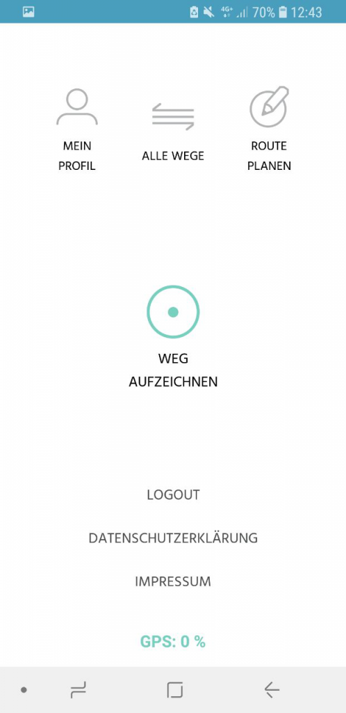
All recorded routes are saved and can be viewed again and again by the app user. In addition, alternatives to these routes can be calculated to help the app user better adhere to the preferences they have defined.
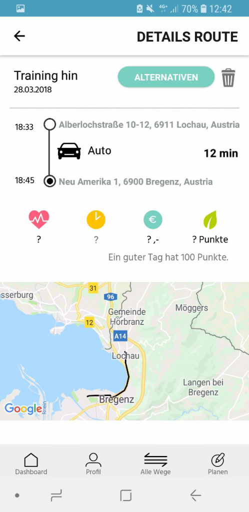
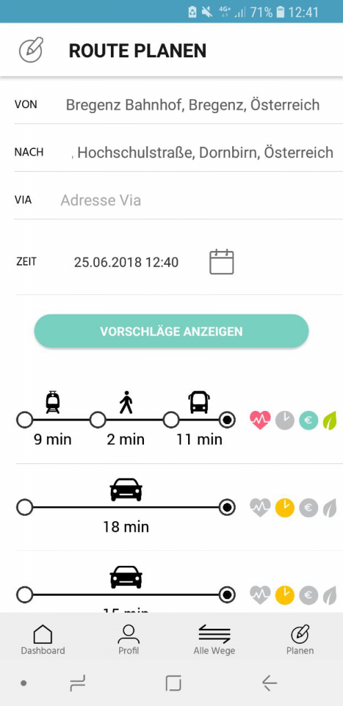
For planning new routes, any start and destination locations can be entered. Based on the profile data (existing means of transport, preferences and thresholds), corresponding routes are then loaded from several routing providers, the user preferences are analyzed and the routes found, including their rating, are displayed.
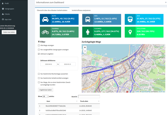
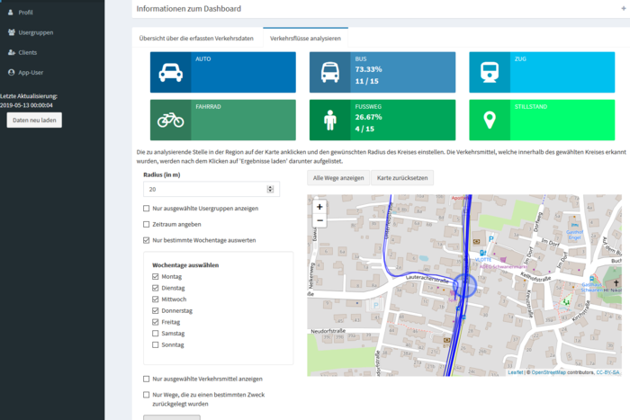
Web application to analyze the paths recorded and shared by users
The Mobility Choices analysis application involves the design and implementation of an analysis tool for evaluating real-world traffic flows, in the form of GPS tracks recorded using the Mobility Choices app. Based on the requirements for widely used traffic analysis methods, such as KONTIV, a flexible, modular and easily configurable analysis tool was created that allows the available tracks to be filtered, evaluated and displayed according to various parameters. Relevant parameters for this are e.g. means of transport, time periods, geographical regions or user groups. Various data mining techniques were used for this purpose. Since the application should be operable via the web, the programming language R with the plug-in Shiny was chosen for the implementation. The innovation lies in the fact that the evaluations of traffic flows can be carried out with the help of the developed tool using real recorded traffic data and no longer have to be collected from questionnaires afterwards from the participants, which are inherently inaccurate and prone to errors. This leads to a more reliable data basis and, as a result, better analysis results.
Project goals were:
Apart from the overall goal of sustainable mobility and the associated reduction of greenhouse gas emissions, the project pursued the following objectives:
1. creating a basis for decision-making for authorities, municipalities or organizations (socio-political level)
2. Promoting sustainable behavioral change with the help of behavioral-economics-based measures (individual-social level)
As part of the project, a free-to-use smartphone-based application (app) was developed that is tailored to the public transport services offered in the cross-border Lake Constance region and can be adapted to individual user preferences. The app is supplemented by an evaluation option that helps participating (e.g. municipal) agencies to carry out customized and time-limited evaluations of traffic flows based on participating (or short-term activatable) app users.
The anonymized data collected via the apps can be used
- for immediate feedback to users to encourage them to change their transportation behavior based on their own preferences,
- for analyzing traffic flows, especially in terms of observable changes and trends (also relevant without being representative for the overall population), taking into account near real-time data
- to determine traffic behavior in the regions studied,
- to optimize existing public transportation services,
- for the evaluation of measures in the transport sector with an immediate feedback possibility
- for urban planning (e.g., access to public buildings, shopping, services, residential areas),
- to better understand the preferences and response rates of specific target groups, such as commuters.
As far as the use of nudging measures is concerned, the aim is to find out which accompanying measures are suitable for influencing traffic behavior in which target groups under which general conditions.
The following measures are planned as part of the project:
- Recording the travelled routes of the participants with automatic means of transport recognition via smartphone app and showing the impact on environment, costs, health
- Generating suggestions for alternative transportation mode combinations along given origins and destinations based on user preferences
- Based on behavioral economics, measures for trial modal change and monitoring of the success achieved thereby with respect to these criteria
In field tests, the behavioral impact of using the app on mobility decisions will be investigated. With the evaluation of the real mobility data, the public transport offer and infrastructure planning can be optimized in the long term.
